A map I made as a sort of a joke about a lovely place in Brisbane – but it’s tiny and we didn’t put in our Family Bushwalks book.

Brisbane City
A map I made as a sort of a joke about a lovely place in Brisbane – but it’s tiny and we didn’t put in our Family Bushwalks book.
My new book created with Gillian Duncan is now available for purchase at www.familybushwalks.com.au. It’s our third book, following two books of recreational trails for cyclists; this one is aimed at walkers and runners who want to go bush without committing to long distances or lots of climbing.
300 walks are described in detail including of course a brand new fully researched topo map showing all points of entry, resources like water and shelter, and making clear the effort required to complete the walk.


In 2010 I helped Meg Gordon and the Centenary Suburbs Historical Society (www.cshsoc.org.au) by drawing the maps for their book “Pastoralists of Brisbane Town’s Fringe / Pioneers of Seventeen Mile Rocks and Wolston.”
At the time I lived in the centre of this map.

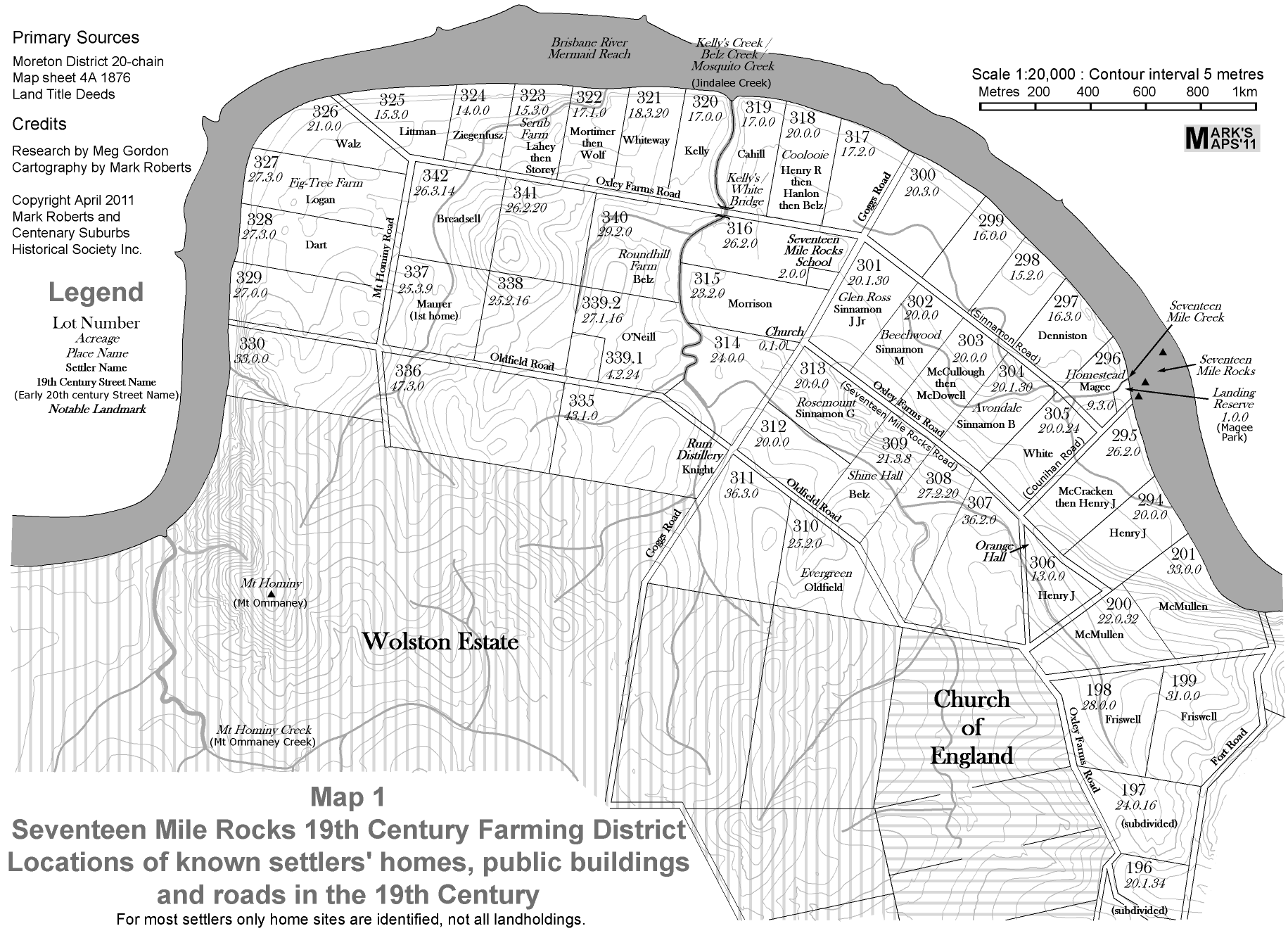
In 2011 I collaborated again with Meg Gordon and the Centenary Suburbs Historical Society (www.cshsoc.org.au) by drawing the maps for their impressive publication “When River Was Roadway”, subtitled “Pioneer Farmers of Brisbane’s Seventeen Mile Rocks District”.
It is a monochrome publication, and I went with a not so subtle “old world” feel to the typography where it referred to older features and a more modern look for modern features. Here is one of several maps which appear in the book:
A map which don’t make it into our Family Bushwalks book. I used to live round the corner and help with bushcare here.

A map which didn’t make it into our Family Bushwalks book but would have been good for our Family Rides book. The information icons are signs about historical points of interest. A trail of these continues south along a bike path.

A draft orienteering map of a school which will one day be fieldworked by a friend, so for the moment it lacks the usual detail:

This is my “biggest” map ever – it was printed at I think A0 size and put on a sign at the entrance to my sons’ school a few years ago:

My son’s school asked me to create these a few years ago. I made dozens of them, each one customised not only to the building it is in, but also the wall it is mounted on.
First I stared long and hard at the traditional diagrams and decided they were almost useless. They are horribly cluttered, carry far too much irrelevant information, and they try to say two things at once – Evacuation Routes and locations of Safety Equipment.
I wanted to make something that didn’t just address statutory requirements, but actually enhanced safety. My solution was two make two quite separate diagrams, each containing only the bare minimum of information, and to orient the Evacuation Diagram to correspond to its location.


I used Sketchup for this one – an accurately measured 3D representation of my 3 year old son’s classroom “Waratah” at Brisbane Montessori School.
It doesn’t look like a regular school classroom, because Montessori classrooms emphasise individual learning using the specially designed equipment which is stored on the shelving throughout the room.
I was very pleased with the outcome of this project; it evokes the room well in a slightly antiseptic way.

