The Lab is a weekly opportunity for “high functioning autistic” (aka Asperger’s) teenagers to get together and make things on their computers with guidance from adult mentors. It’s challenging to find so I volunteered a map:

The Lab is a weekly opportunity for “high functioning autistic” (aka Asperger’s) teenagers to get together and make things on their computers with guidance from adult mentors. It’s challenging to find so I volunteered a map:
Two A3 maps of a chunk of the Gold Coast for the Great Adventure Challenge 2015 run by Gary at maxadventure.com.au and raising remarkable sums of money for the Starlight Children’s Foundation. Participants ran, paddled and rode between 4 and 7 hours to complete the courses:


My brand new orienteering map of Silkwood School. The former owner(s) of the land still live in the two houses on the hill:

The open areas used to be a plant nursery and are being progressively planted and rehabilitated. Glossy Black cockatoos have been recorded here.

In 2010 I helped Meg Gordon and the Centenary Suburbs Historical Society (www.cshsoc.org.au) by drawing the maps for their book “Pastoralists of Brisbane Town’s Fringe / Pioneers of Seventeen Mile Rocks and Wolston.”
At the time I lived in the centre of this map.

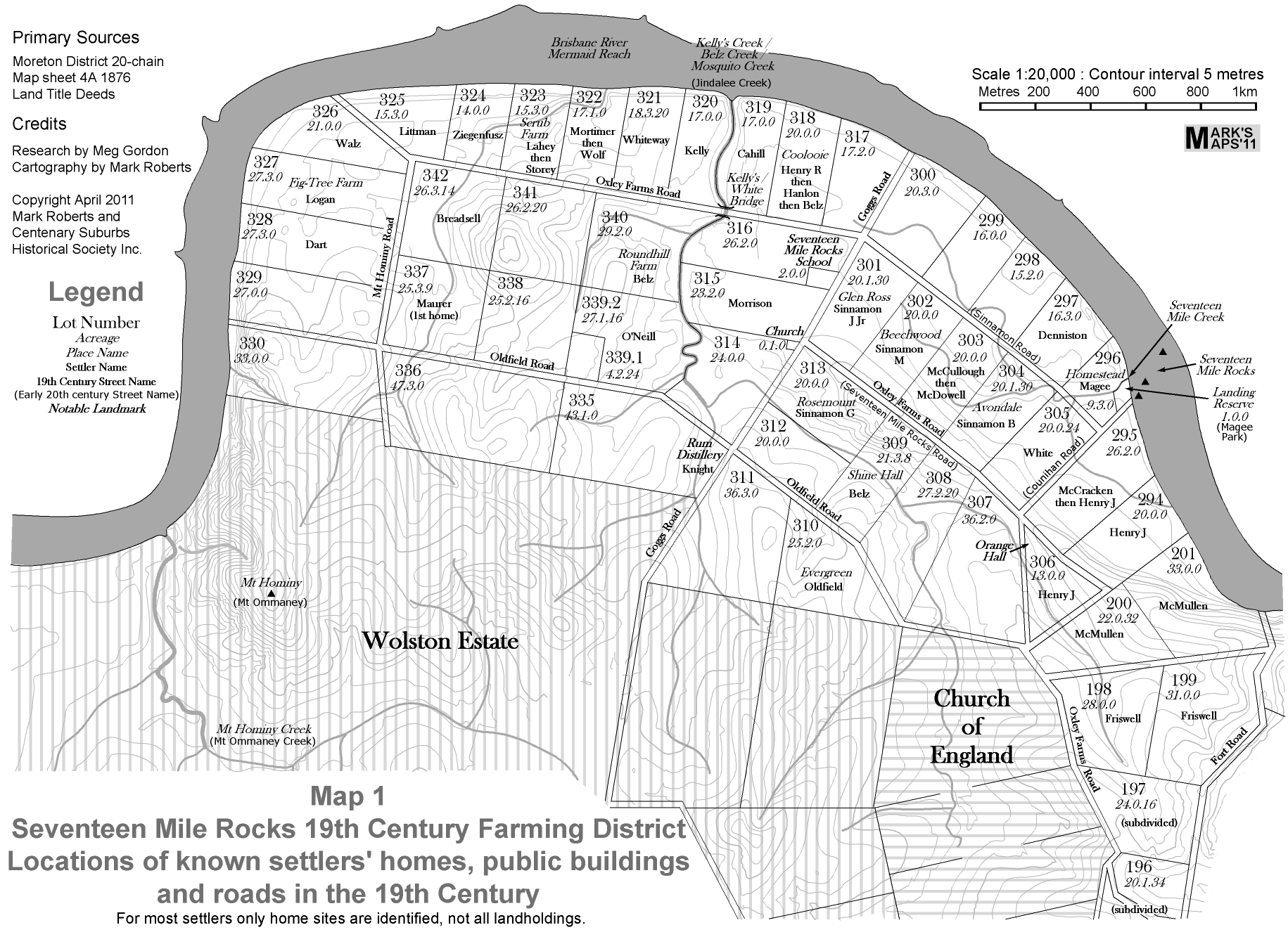
In 2011 I collaborated again with Meg Gordon and the Centenary Suburbs Historical Society (www.cshsoc.org.au) by drawing the maps for their impressive publication “When River Was Roadway”, subtitled “Pioneer Farmers of Brisbane’s Seventeen Mile Rocks District”.
It is a monochrome publication, and I went with a not so subtle “old world” feel to the typography where it referred to older features and a more modern look for modern features. Here is one of several maps which appear in the book:
Thanks to Tim Roberts (no relation) and Meg Gordon for their help with this.
This map shows a number of contiguous reserves managed by Ipswich City Council (ICC) and (we think) the Queensland Government Department of Environment and Heritage Protection. The open area at the northern tip used to be a gravel quarry; ICC plans to develop it for recreation, but the area gets inundated and sometimes scoured during flood events.
The darker green on this map shows one of the few remaining areas of Rainforest on the Brisbane River. There are known to be overgrown trails in there and part of the ICC plan is to open them up through to Camerons Scrub.
Update: the latest version of this map includes substantial additional Council reserve identified at the SE corner.Sapling Pocket

The northernmost and one of the lesser Glass House Mountains, Mt Coochin has no formal walking trails to the twin peaks. Protective clothing, stout shoes and a sense of humour may be advisable, but lots of adventurous families make it to the top(s) every year. We have not visited this map so the details cannot be entirely trusted:

This trail was rejected for our Family Bushwalks book because it is in poor condition.

A map which don’t make it into our Family Bushwalks book. I used to live round the corner and help with bushcare here.
