Sunday, 27 February 2005
State Event, Hardings Paddock, Purga, Ipswich

08:00 Sunday 27th February 2005
"Hardings Paddock" (Goolman Conservation Reserve) 2003 1:10,000
10 controls 4.7km 200m climb (4.3%)
50km SW of Brisbane CBD Cunningham Highway - Ipswich / Boonah Road - Carmichael Road - Purga Cemetery Road
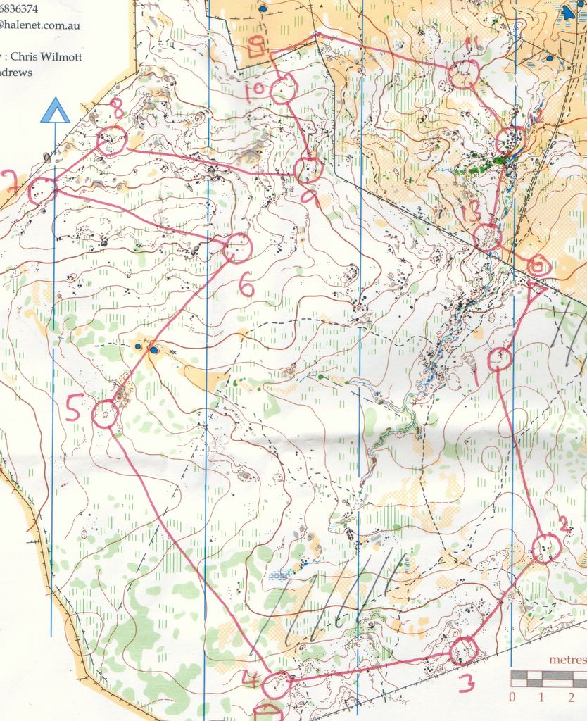
I wasn't feeling my best and after atacking number 2 twice and drifting into the reentrant to the west of it both times I lost interest and DNFed at number 3. What a shocker.
Thanks to Elizabeth for the lift and Nev for arranging it; Robin and Chris Spriggs and Ugly Gully for the event; Rob Simson and QOA for the map; and Ipswich City Council for (very) hard-won permission to run the event.
Saturday, 26 February 2005
Park-O, Brisbane Botanic Gardens, Mt Coot-tha, Toowong, Brisbane

15:00 Saturday 26th February 2005
"Brisbane Botanic Gardens" 1:5,000 5m
UBD158 L14, 6km W of Brisbane CBD
16 controls 2.7km 125m climb (4.6%)
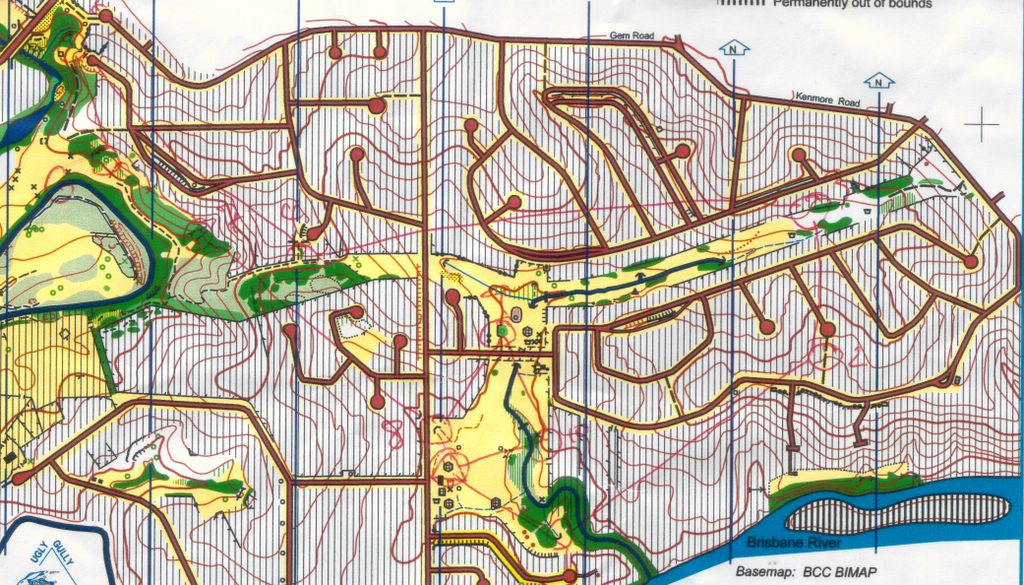
The maze of paths in the gardens are designed not for getting from A to B for leisurely strolls going nowhere at all. The garden areas in between are marked out of bounds. Excellent course setting made the most of the traps this creates and it became apparent by the second leg that thorough planning of each leg before leaving the previous control was vital. Standout route choice was all the way round the lake on 10-11.
I made procedural errors on two legs (starting off on the wrong way round the loop on both the southern and northern loops!) and got very tued up on the tracks on 1 and 2. My time of 33 minutes was way off the pace.
Thanks to Queensland Forest Racing for the event and Ugly Gully / Jon Sutcliffe for the map.
Thursday, 24 February 2005
Mid-Week Event, DMHenderson Park, Macgregor, Brisbane

09:00 Thursday 24th February 2005
"Mimosa Creek" 2004 1:5,000 ?5 metres
14 controls 3.75km 55m climb (1.4%)
UBD201 A16 12km SSE of Brisbane CBD
Thanks to Rob Simson for the event, and Rob Simson and Toohey Forest for the map.
Sunday, 20 February 2005
OY, Dalmoak, near Stanthorpe
09:00 Sunday 20th February 2005
"Dalmoak" 2000 1:15,000 5m
158km SE of Brisbane CBD (200km by road)
13 controls 7.1km 140m climb (2% climb)
This is course 2 and it took me 78 minutes, way off the pace (51 min) despite feeling like I had run OK. That's a shocking 11mpk which is best explained by the amount of time it takes to pick through the terrain to find the controls reliably.
I drifted right on the way to 9 and relocated on the fence but otherwise wasted only a little time here and there.
An excellent course with challenging legs all round, except perhaps for the assistance from the fences at 3, 4, 7, 8, 9, 10, 13.
I never did find the ruined fence between 4 and 5.
Thanks to QOA and Eric Andrews for the map, BBB and Eric Andrews for the excellent event.
Thursday, 17 February 2005
Mid-Week Event, Misty Morn, Kenmore, Brisbane
09:00 Thursday 17th February 2005
"Misty Morn" 2004 1:10,000 5m
UBD 177 J15 10km WSW of Brisbane CBD
4km 10 controls 140m climb (3.5%)
2-3 is a beautiful trap which many runners fell into despite having the whole trudge up the hill from 1 to make their route choice. Possibly the Out of Bounds symbol is difficult to read when it represents a narrow strip of houses.
Most of the straight roads on this map run magnetic NS/EW.
Thanks to John Cooper for recent updates to a map fieldworked by Uncle Tom Cobbley and owned by QOA. Thanks to Nev Cobbold for a good course.
Sunday, 13 February 2005
Street event, Landsborough Streets, Sunshine Coast
09:00 Saturday 13th February 2005
"Landsborough" 1:17,500 5m
UBD Sunshine Coast 96 K17
60 minute score event really designed for cyclists. I did OK despite a bad loop choice.
Hmmm... the railway runs magnetic N-S!
Thanks to Cath and Gordon Howitt and Sunshine Orienteers for the map and the event.
Thursday, 10 February 2005
Mid-week event, Kalinga Park, Clayfield/Wooloowin, Brisbane
09:00 Thursday 10th February 2005
"Kalinga" 1992 1:8,000 2m
UBD140 G2 6km N of Brisbane CBD
15 controls 5.6km 55m climb (1%)
Scatter event. The pipe across the creek between 13 and 11 was under water when I got there so I had to go round by the road bridge to the right. This map is rather out of date!
Thanks to Jim Bowling for the event and QOA for the map.
![]()
Subscribe to Posts [Atom]