Sunday, 31 July 2005
State Event, Bright View, south of Ipswich
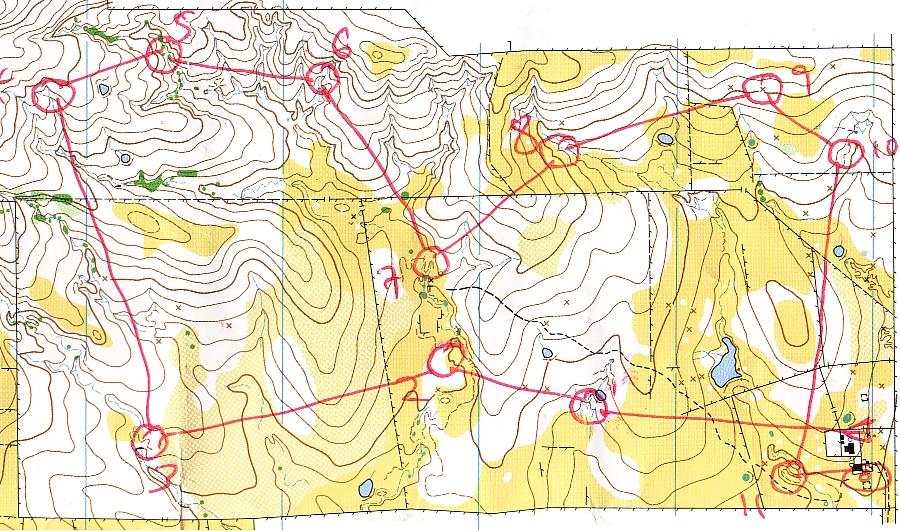
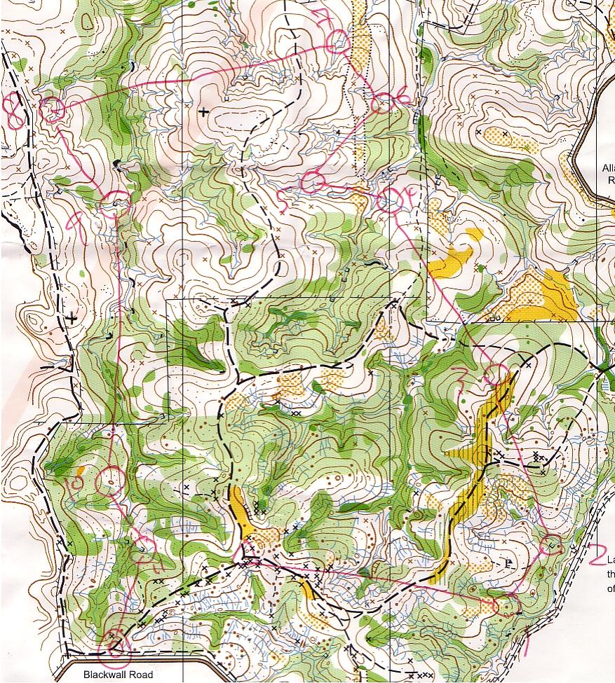
09:00 Sunday 31st July 2005
"Bright View" 2005 1:15,000 5m
"Red 3"
I think this is only the 2nd 1:15,000 map I have run on this year. Once again the property boundaries are neatly arranged to Magnetic North.
On much of the map, the grass is very long. This impeded progress not because of pushing through but because there were plenty of rocks and dead wood under it which I couldn't see. I nearly came a cropper several times. Once again tracks made by livestock were very valuable, often springing up just where I was going; although this sometimes led me astray!
Thanks to Eric and QOA for the excellent map, Tony and Greg for the event. Apparently the map is brand new and previously unused; it was created for an event that didn't happen.
Sunday, 24 July 2005
Badge Event, Old Hidden Vale, Grandchester

09:00 Sunday 24th July 2005
"Old Hidden Vale" 2004 1:15,000 5m
"Red 4" (M45A) 12 controls 7.4km 250m climb (3.4%)
A 1.5km climb to the start meant everyone was nicely warmed up. More Lantana than the map suggests - a common experience recently. For most of my run I thought the map was 1:10,000 and constantly wondered why everything took so long! It felt like a fairly steep course and with plenty of roundabout route choices so my 78 minutes (>10mpk) seemed OK to me but I wasn't real happy when I saw 49 minutes on the board. I wasn't slowest in my class.
It all went very smoothly, except for climbing a little higher to the right than was necessary on 3>4 and 5>6. In both cases it was difficult to assess how much climbing to do on the traverse. Or to put it another way, I didn't try hard enough. I spiked everything.
Splits 8:19 3:38 11:56 6:05 10:50 9:09 7:48 2:50 1:33 6:55 3:51 4:38 0:44
This is my 3rd run on this map.
Thanks to Eric and QOA for the map, Trevor and David for the event, Lisa and Alex for the company on the trip.
Thursday, 21 July 2005
Mid-Week Event, Sherwood, Brisbane
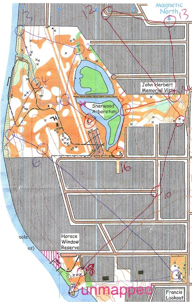
Thursday 21st July 2005
"Sherwood" 2005 1:5,000 5m
UBD178K19 9km SW of Brisbane CBD
"Long" 3.7km 16 controls 115m climb (3.1%)
What an excellent map. OK so I drew it myself. This was the first time it has been used, although an earlier map was well used many years ago. I started again from the aerial photos.
I've traversed the "unmapped" area a couple of times so I knew it was runnable, so that's how I got from 7 to 8. No surprises otherwise. I took 32 minutes, 8.6mpk; the winner took 25 minutes.
Unfortunately Fiona had to work with a copy of the map from which the very top had been cropped, obscuring the fact that you can get from 12 to the parkland to the west quite easily. I had been unhappy with the scale marked on the map and after the event Fiona confirmed that it was wrong by comparing with the old map. It's marked as 1:5,000 but is actually around 1:6,000.
Thanks to Fiona Calabro for the event.
Sunday, 17 July 2005
State Event, Bunyaville, Brisbane
09:00 Sunday 17th July 2005
"Bunyaville State Forest (West)" 2003 1:10,000 5m
UBD118G5 13km NW of Brisbane CBD
"Red Medium" 5.2km 245m climb (4.7%)
Another fairly brutal course, steep and tough underfoot.
1>2 I followed the track to the right; 2>3 via the road; 3>4 by road and track which I think was much faster than going direct. However I missed 4 on the way past - the knoll wasn't recognisable from the south (it's a degraded rootstock) and the flag was hung at ground level. That cost a couple of minutes. Tracks to the left on 9>10 again.
My time was 71 minutes, 16 minutes off the pace, about a third of the way down the field.
This was my 2nd or 3rd run on this map.
Thanks to the Cavanaghs and TF for the event, Jon and QOA for the map.
Thursday, 14 July 2005
Mid-Week Event, Mt Crosby, Ipswich
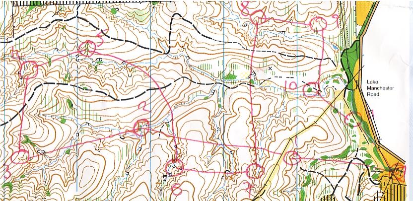
12:00 Thursday 14th July 2005
"Mt Crosby" 2005 1:10,000 5m
UBD174 G15 23km WSW of Brisbane CBD
"Long" 11 controls 3.95km 250m climb (6.3%)
Another excellent event from Clive Pope. The gully system in this part of the map is very deceptive, and indeed it deceived a few people today. Thankfully I was alert for the danger and all went well until the rules changed on numbers 10 and 11 which aren't terrain features. Somehow I didn't have the control descriptions for these two so I wasn't sure what I was looking for; and I allowed the green blobs to dominate my thinking - not the best approach in a sea of Lantana. As soon as I started looking at the terrain instead (see the juicy gully behind no 10?) it all got much easier.
The map even has printed upon it a homily from Geoff Peck: "Contours are for navigating, vegetation is for route choice."
I thought I'd had a reasonably good run until I discovered that a 12 year old had beaten me (and his dad.) I think I came 4th, 3 or 4 minutes off the pace in 52 minutes, which is 13mpk. Not fast, but the terrain is brutal. Anne said something about "Payback time."
Thanks to CP for the event, QOA, UG and Geoff Peck for the map.
Sunday, 10 July 2005
State Event, Bluestone Creek, Chuwar, Ipswich
09:00 Sunday 10th July 2005
"Bluestone Creek South" 2002 1:10,000 5m
UBD 193 J9 27km ESE of Brisbane CBD
"Red 3" 4.5km 220m climb (5%)
My second run on this map. I thought I had run reasonably steadily despite recovering from a cold but my 63 minutes doesn't look real good alongside Trevor Sauer's 47 minutes; I was 15th of 38 on the course.
Running without descriptions (they had run out) was no problem apart from no 2 which was "foot of waterfall" and of course approaching from above I couldn't see the waterfall and I certainly couldn't see the flag. This cost me a minute or so. I still haven't really adjusted to looking for flags hung so close to the ground.
The only significant rout choice was 7>8 where I contoured to th right then followed the valley to the cliff where it got a bit confusing. Sensing trouble, I was very careful; others were not so lucky. It was easy to overlook the gully from the cliff to no 8.
The green on the ap is OK in the valleys (lantana) but very out of date on the hillsides despite being only 3 years old. CP told me that there was limited checking of the vegetation last time.
Thanks to Ian, Anna and UG for the event; EA, CP and QOA for the map.
![]()
Subscribe to Posts [Atom]